Customs Confiscation and EUDR: The European Methodology of Satellite Tracking
The Algorithmic Panopticon of European Customs
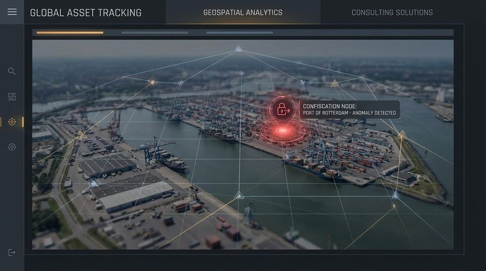
The enforcement of the European Union Deforestation Regulation (EUDR) relies on a technological infrastructure that completely removes human discretion from border control. European customs authorities have integrated their Information System directly with the Copernicus satellite network and the EU Observatory on Deforestation. This creates an algorithmic panopticon that evaluates the legal status of Latin American agricultural commodities before the cargo vessel even docks at Rotterdam or Antwerp.
If a Brazilian exporter submits a Due Diligence Statement containing geolocation data, the European customs algorithm instantly cross-references those coordinates against time-stamped satellite imagery. The algorithm mathematically determines if the exact plot of land was subject to forest degradation or suppression after the December 31, 2020 cut-off date. There is no negotiation; if a single pixel of the georeferenced polygon indicates post-2020 deforestation, the algorithm triggers an automatic border blockade.
The Financial Mathematics of Cargo Confiscation
Many C-Level executives incorrectly equate EUDR enforcement with administrative fines. While the 4% global turnover fine is a severe threat, the immediate operational reality is far more brutal: absolute cargo confiscation.
Under EU law, customs authorities are legally mandated to seize and confiscate products that fail the satellite verification test. This is an immediate, catastrophic hit to the Profit and Loss (P&L) statement.
- 100% Asset Loss: The exporter suffers the total loss of the Cost of Goods Sold (COGS). The physical cargo is confiscated and legally barred from entering the Common Market or being re-exported to secondary buyers.
- The Demurrage Hemorrhage: During the investigation phase leading up to confiscation, the cargo is retained at the port. The exporter accrues massive daily demurrage and storage fees, which rapidly exceed the commercial value of the stranded asset.
- Contractual Contagion: The failure to deliver triggers immediate default clauses in the procurement contract with the European off-taker, resulting in lost future revenue and severe indemnification penalties.
(Source reference: Official European Commission EUDR implementation guidelines on customs enforcement and Copernicus satellite data integration).
The Polygon Burden of Proof
The legal burden of proof under the EUDR rests entirely on the exporter, and that proof must be geometric. Providing a simple GPS point coordinate is legally insufficient for properties larger than 4 hectares.
Exporters must provide a complete, georeferenced polygon outlining the exact perimeter of the production area. If a Brazilian agribusiness relies on unverified Tier 2 or Tier 3 aggregators who cannot provide these precise, satellite-verifiable polygons, the entire export volume is mathematically presumed to be illegal. Attempting to export aggregated commodities without this forensic geospatial data guarantees an algorithmic collision at the European border.
The Villanova ESG Shield: Strategic Intervention
At Villanova ESG, we do not leave your cross-border cash flow to the mercy of European satellite algorithms. We engineer your geospatial data to guarantee safe passage through the most aggressive customs checkpoints. We protect your corporate valuation through our four uncompromising pillars:
- Logistical Reality Audit: We dismantle the risk of satellite detection. Before your cargo ever leaves Latin America, we execute preemptive geospatial forensics. We utilize advanced satellite tracking to audit your supply chain polygons against the exact Copernicus database used by European customs, identifying and isolating contaminated hectares.
- Cross-Border Regulatory Shield: We architect your operational data to perfectly map into the EU Information System. We ensure that the polygons submitted in your Due Diligence Statements are structurally flawless and algorithmically verified as deforestation-free, neutralizing the risk of customs confiscation.
- P&L and Revenue Protection: We defend your balance sheet from total asset loss. By securing algorithmic clearance for your shipments, we protect your EBITDA from catastrophic demurrage costs, cargo seizure, and the financial devastation of breached European contracts.
- Cost of Capital Optimization: International credit syndicates categorize EUDR confiscation as a high-probability default event. We leverage your audited, satellite-verified supply chain data to prove absolute regulatory resilience, utilizing this asset to secure Sustainability-Linked Loans (SLLs) and structurally reduce your Weighted Average Cost of Capital (WACC).
European customs algorithms are actively scanning your supply chain from space. Do not leave your export revenue exposed to automatic cargo confiscation. Contact our risk assessment team immediately to structure your cross-border regulatory shield and audit your geospatial data at contact@villanovaesg.com
Marcio Villanova CEO, Ecobraz | Founder, Villanova ESG